


Ridin’
Motorcyclin’

Head of the Dragon
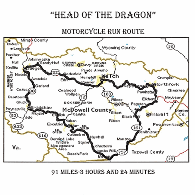
91 miles of McDowell County two lane country roads. Riders that complete the dragon motorcycle rides will attain “Dragon Master” status. headofthedragonwv.com

Heaven's Gate
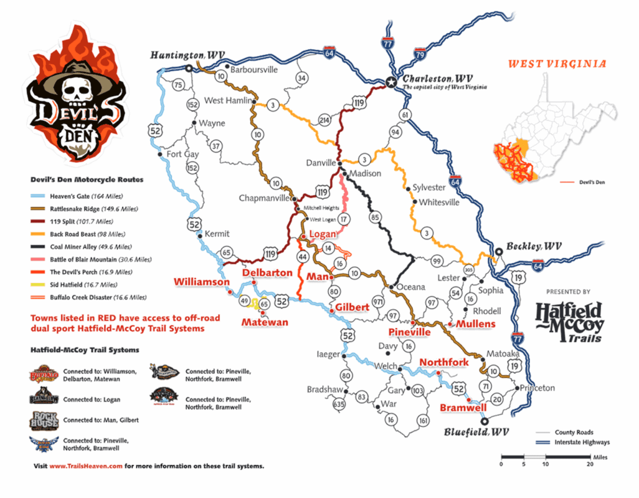
Heaven’s Gate Motorcycle Route, a section of the Devil's Den trail system, is a 164 miles self guided motorcycle tour, starting in Bluefield and ending near Huntington, West Virginia, along Route 52.
Head of the Dragon

Heaven's Gate West Virginia
Ridin’ the Trails

ATV Trails
The Hatfield-McCoy Trail System

Indian Ridge
Ashland, WV
Pinnacle Creek
Pineville, WV
Pocahontas
Bramwell, WV

Warrior
War, WV
ATV Trails
The Hatfield-McCoy Trail System
The Hatfield-McCoy Trail System is a statutory corporation created by the West Virginia Legislature to generate economic development through tourism in nine southern West Virginia counties. The Hatfield-McCoy Trail System covers hundreds of miles of off-road trails. All of the trail systems are open throughout the year to ATVs, dirt bikes and utility vehicles. Many of the trail systems also offer community connecting trails that allow visitors to access ATV-friendly towns to experience the charm of southern West Virginia.
McDowell County allows you to connect to three popular Hatfield-McCoy trails including Indian Ridge, Pocahontas and Pinnacle Creek. No matter which trail system you choose, Hatfield-McCoy Trail System visitors can expect to find a variety of paths ranging in activity level difficulty. These are not your typical “flatlander” trails, however, and can be a challenge for a first-time rider. For this reason, visitors may choose from a list of ATV guided tour and rental providers online at www.trailsheaven.com
The overall goal of the Hatfield-McCoy Trail System project is to develop a world-class trail system with an emphasis on safety in each of its nine project counties throughout southern West Virginia. Project estimates have concluded that once the trails are developed and linked, there may be as much as 2,000 total miles of trails.
Get Ready to Get Dirty!
Gear up for an adventure you won’t soon forget! McDowell County offers an extensive route of exciting ATV trails on the Hatfield-McCoy Trail System. Certain Rules and Regulations apply to the Hatfield-McCoy Trail System.
General Rules
User Permits required.
Everyone must wear a DOT or SNELL approved helmet and eye protection.
All operators and passengers on an ATV, UTV, or motorcycle must follow manufacturers’ recommendations.
All operators and passengers on an ATV, UTV, or motorcycle must meet manufacturers’ minimum age requirements. No booster or car seats are allowed.
Obey all signs, gates, and barriers.
Stay on marked trails.
Adult supervision is required for those under age 16.
Do not leave any trash or litter behind.
No alcoholic beverages may be consumed or carried.
Drive or ride at a speed reasonable for conditions.
No camping.
Firearms are allowed. If the firearm is a handgun for personal protection, then you can carry it concealed or unconcealed, loaded or unloaded, whether you have a concealed carry permit or not. If it is a long gun that you are using for hunting purposes and are traveling on the Trail System to get to a hunting location, it must be unloaded and cased while on the Trail System. No hunting is allowed from or on the Trail System itself.
No fires.
Stay alert at all times, be aware of oncoming traffic.
Trails only open during daylight hours.
ORV-Specific Rules
ORVs are ONLY permitted on the Bearwallow trail system.
Drivers and passengers are required to wear helmets.
Drivers and passengers must have valid trail permits.
A valid driver’s license is required to operate an ORV.
All passengers must be over 8 years of age, or 4’9” tall. No booster or car seats are allowed.
Seat belts must be worn at all times. The number of passengers is limited to the number of factory installed seat belts.
ORVs are required to have a roll cage on all most difficult (black and black/red) trails.
UTV-Specific Rules
The driver and passengers of a UTV must:
Wear seat belts at all times; the number of passengers is limited to the number of factory installed seat belts.
Keep their hands, arms, feet, head and legs inside the vehicle at all times during operation.
Possess a valid owner’s manual for the machine being operated that is able to be produced upon request.
Stay on designated trails. UTVs are permitted on easiest, more difficult, and select most difficult trails (signed accordingly).
UTVs must be equipped with a steering wheel and roll-over protection system from the manufacturer. Low pressure tires required.
Learn more about the Hatfield-McCoy Trail System at www.trailsheaven.com
Indian Ridge Trail
Located near Ashland, WV, this system offers a nice variety of trails of all difficulty levels. This trail system offers community access to the ATV-friendly towns of Northfork and Keystone. Nearby communities offer gas, food and lodging. The trail system also connects with three other Hatfield-McCoy Trail Systems — Pinnacle Creek, Pocahontas, and Warrior — to allow extended offroad trips.
Trailhead Amenities
» 2-acre parking area/Restroom facilities
» Permits are not available at Indian Ridge trailhead. Guests may purchase permits at any authorized retailer (see pages 34-39), or online at www.TrailsHeaven.com.
Indian Ridge trailhead is not staffed. All Hatfield-McCoy Trails are open 365 days a year from half an hour before sunrise until half an hour after sunset.
Driving Directions
TRAILHEAD LOCATION
In the town of Ashland, WV near Northfork, WV
Driving north or south on Interstate-77, take Exit 1, follow truck route US 52 N through Bluefield to US 52 North 26.3 miles to Northfork, make a sharp right turn North onto Country Road 17 (Northfork-Ashland Road). Continue on County Road 17 another 6.5 miles to the entrance of the Ashland Trailhead.
Pinnacle Creek Trail
Pinnacle Creek, with direct connections to the ATV friendly towns of Mullens and Pineville, WV, is known for its breathtaking scenic views and proximity to world- class whitewater rafting and snow skiing — both less than an hour away. This trail system has direct access to gas, food and lodging. The trail system also connects with three other Hatfield-McCoy Trail Systems — Indian Ridge, Pocahontas, and Warrior — to allow extended off-road trips.
Trailhead Amenities
» 2-acre parking area/Restroom facilities
» Permits and souvenirs available
Pinnacle Creek trailhead is staffed from 9:00 a.m. to 2:00 p.m., 7 days a week (except major holidays). All HatfieldMcCoy Trails are open 365 days a year from half an hour before sunrise until half an hour after sunset.
Driving Directions
TRAILHEAD LOCATION
2733 Pinnacle Road, Pineville, WV 24874
From I-77, take the Robert C. Byrd exit near Beckley. Travel south on Rt. 16 toward Sophia 3.5 miles. Make right on to Rt. 97/54 toward Twin Falls State Park. At the intersection of Rt. 97 and Twin Falls State Park entrance, make a right continuing on Rt. 97 toward Pineville. At the intersection of Rt. 97 and Rt. 10, bear left onto Rt. 10 south. Travel approximately 1 mile and turn right onto Route 16 south. Travel 1⁄2 mile then turn left following the signs for the Pineville trailhead. Finally, drive 2.8 miles to the trailhead center which is located on the left.
Pocahontas Trail
Pocahontas Trail System links up to three other HatfieldMcCoy Trail Systems — Indian Ridge, Pinnacle Creek, and Warrior — making for the most continuous miles of trails east of the Mississippi. The trailhead is located in Coaldale, just outside of the town of Bramwell, historically known for its numerous millionaire homes from the early 20th century. This trail system has direct access to gas, food and lodging.
Trailhead Amenities
» 2-acre parking area/Restroom facilities
» Permits and souvenirs available
» Pocahontas trailhead is staffed from 9:00 a.m. to 5:00 p.m., 7 days a week (except for major holidays). All Hatfield-McCoy Trails are open 365 days a year from half an hour before sunrise until half an hour after sunset.
Driving Directions
TRAILHEAD LOCATION
11110 Coal Heritage Rd, Bramwell, WV 24715
Driving north or south on I-77, take Exit 1 at Bluefield. Follow US 52 N for approximately 20 Miles to Coaldale. Trailhead is located on the right.
Warrior Trail
The Warrior Trail System is located in the City of War which is West Virginia’s most southern city. This trail system also accesses the ATV-friendly City of Gary. The Warrior Trail System offers numerous scenic views and has direct access to gas, foods and lodging. Connects with three other trails — Pinnacle Creek, Indian Ridge, and Pocahontas.
Trailhead Amenities
» 2-acre parking area/Restroom Facilities
» Permits and souvenirs available
» Warrior Trailhead is staffed from 9:00 a.m. to 2:00 p.m., 7 days a week (except major holidays). All HatfieldMcCoy Trails are open 365 days a year from half an hour before sunrise to half an hour after sunset.
Driving Directions
TRAILHEAD LOCATION